Indoor mapping is the creation of maps of the interiors of buildings, such as shopping malls, airports, hospitals, and offices. It involves using special software and hardware, such as laser scanners and cameras, to create detailed maps of indoor spaces, including the layout of rooms, corridors, and other interior features, as well as details like furniture and equipment.
Indoor mapping has become increasingly important as more people rely on mobile devices and technology to navigate indoor spaces. With indoor maps, people can find the locations of stores, restrooms, and other amenities more easily, making it simpler to get around (see https://mappitall.com/indoor-location-services for instance).
Indoor mapping is used across many industries, including retail, healthcare, transportation, and education. For example, retailers can use indoor maps to guide customers to specific products or promotions, while hospitals can use them to track the location of patients, staff, and medical equipment.
What is Indoor Mapping Software?
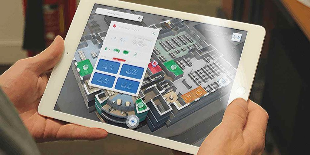
Indoor Mapping Software is a technology that enables the creation and visualization of indoor maps and navigation systems for various indoor spaces such as buildings, malls, airports, museums, and more. The software allows users to view, search and locate specific points of interest within the indoor environment, such as rooms, departments, facilities, and amenities.
Technologies
Indoor mapping software uses a combination of technologies such as WiFi triangulation, Bluetooth beacons, and sensors to map the indoor environment and create accurate indoor maps. The software also allows for the creation of 3D models of indoor spaces, which can be used for visualization, analysis, and planning purposes.
Applications
Indoor mapping software has a wide range of applications such as indoor navigation, asset tracking, facility management, and marketing. For example, indoor mapping software can be used in a shopping mall to help customers find specific stores or products, or in a hospital to help patients navigate to different departments and facilities.
Choosing the best Indoor Mapping Software
There are several indoor mapping software options available on the market today, each with its own set of features and capabilities. Some popular indoor mapping software options include:
-
Mappitall: Mappitall is an indoor mapping software platform that provides a range of services for creating, managing, and visualizing indoor maps.
-
IndoorAtlas: IndoorAtlas is a software platform that uses geomagnetic technology to create indoor maps and provide indoor positioning services. It is designed to be used in large indoor spaces, such as shopping malls and airports.
-
MazeMap: MazeMap is an indoor mapping software that provides 2D and 3D maps of indoor spaces. It allows users to search for specific locations within the indoor environment and provides detailed directions for navigating to those locations.
-
Mapwize: Mapwize is a software platform that provides indoor mapping and navigation services for a wide range of indoor spaces, including museums, airports, and universities. It offers a range of features such as real-time location tracking, route optimization, and location-based notifications.
-
Jibestream: Jibestream is an indoor mapping software that provides 2D and 3D maps of indoor spaces. It allows users to search for specific locations and provides detailed directions for navigating to those locations. It also offers a range of features such as real-time location tracking and asset tracking.
-
Esri Indoor: Esri Indoor is a software platform that provides indoor mapping and spatial analysis tools for a wide range of indoor spaces, including office buildings, shopping malls, and airports. It allows users to create 2D and 3D maps of indoor spaces and provides a range of features such as indoor routing and location-based analytics.
More about Mappitall
Mappitall provides a range of services that enable businesses and organizations to create, manage, and visualize indoor maps and provide a seamless navigation experience for their visitors, employees, and assets. Some of the services offered by Mappitall include:
-
Indoor mapping: Mappitall allows users to create indoor maps of various indoor spaces, such as buildings, campuses, museums, and malls. The maps can be created using various data sources, such as blueprints, CAD files, or by manually drawing the floorplan.
-
Navigation and wayfinding: Mappitall offers a wayfinding feature that allows users to navigate through indoor spaces and locate specific points of interest, such as rooms, departments, or amenities. The navigation feature can be customized to provide the best route based on the user's location and destination.
-
Real-time location tracking: Mappitall provides a real-time location tracking feature that allows users to track the location of people or assets within indoor spaces. This feature can be used for asset management, employee tracking, or visitor management.
-
Analytics and insights: Mappitall offers an analytics feature that provides insights into user behavior and traffic patterns within indoor spaces. This data can be used to optimize space usage, improve customer experience, and enhance safety and security.
-
Integration with other systems: Mappitall can be integrated with other systems, such as building management systems, access control systems, or IoT devices. This integration enables Mappitall to provide a more comprehensive view of indoor spaces and enables users to make data-driven decisions.
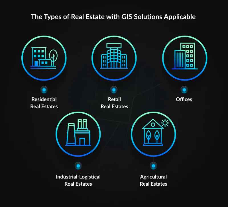
GIS Solutions in The Real Estate Industry
Geographic Information System (GIS) solutions are becoming increasingly important in the real estate industry. GIS in real estate helps professionals to analyze and visualize location-based data, providing insights that can help them make more informed decisions. GIS solutions provide a powerful tool for real estate professionals to analyze and visualize location-based data, providing insights that can help them make more informed decisions and optimize their business operations. Here are some ways that GIS solutions are being used in the real estate industry.
Site selection
GIS solutions can help real estate developers and investors identify potential development sites by analyzing factors such as demographics, land use, zoning regulations, and environmental conditions. By mapping and analyzing these factors, GIS solutions can help real estate professionals identify areas with the highest potential for success.
Market analysisGIS solutions can help real estate professionals analyze real estate markets by mapping and analyzing data such as property values, rental rates, vacancy rates, and demographic trends. By analyzing this data, real estate professionals can identify market trends and make more informed decisions about buying, selling, or leasing properties.
Asset management
GIS solutions can help real estate companies manage their assets by mapping and tracking information such as property locations, condition, maintenance history, and occupancy rates. This information can be used to optimize asset performance, identify maintenance needs, and make data-driven decisions about future investments.
Marketing and sales
GIS solutions can help real estate professionals market and sell properties by creating interactive maps and visualizations that highlight property features and amenities. By providing a visually compelling way to showcase properties, GIS solutions can help real estate professionals attract potential buyers and renters.
Property valuation
GIS solutions can help real estate appraisers and assessors value properties by providing access to location-based data such as property sales, market trends, and zoning regulations. By using this data, appraisers and assessors can make more accurate valuations and provide more informed advice to clients.

Written by Michael Zippo
Michael Zippo, passionate Webmaster and Publisher, stands out for his versatility in online dissemination. Through his blog, he explores topics ranging from celebrity net worth to business dynamics, the economy, and developments in IT and programming. His professional presence on LinkedIn - https://www.linkedin.com/in/michael-zippo-9136441b1/ - is a reflection of his dedication to the industry, while managing platforms such as EmergeSocial.NET and theworldtimes.org highlights his expertise in creating informative and timely content. Involved in significant projects such as python.engineering, Michael offers a unique experience in the digital world, inviting the public to explore the many facets online with him.